


 Southern New England Jewish Ledger
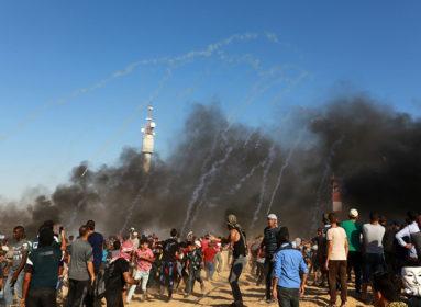
(JNS.org) An exhibition funded by the Norwegian NGO People’s Aid—which is funded by the Norwegian government, among others—displayed paintings of maps that did not mention Israel and labeled all of Israeli territory as “Palestine,” according to Palestinian Media Watch. The exhibition, titled “This is Palestine,” includes maps painted by Palestinian children from Lebanon. One of the maps, called “This is the area of Palestine,” is accompanied by text stating that the area of “Palestine” is “27,009 square kilometers.” That figure represents the size of all of Israel. A second map, showing the “borders of Palestine,” omits any reference to Israel, and a third map displays Israeli cities of Be’er Sheva, Jaffa, Acre, Haifa, and Safed as “the cities of Palestine.”
SHARE